… Goal is a map-shaped adornment that, when in fullest-out zoom view, would allow you to see all the Lower 48 states in one visually coherent unit. On this you could, for instance, link notes to the area of the country where they applied. Eg, material about WalMart big stores could be traced, by mapped icons and links, across the country.
BUT THEN ALSO
… I would love for the separate 48 (or 50) states to behave as 48 or 50 independent adornments, at close enough zoom-ins. This would allow me to see trends with clarity within bigger states and across multi-state regions. I could flag the exact parts of Mississippi and Arkansas with the worst opioid pressure, cross-match that with where corrective efforts were being applied – and zoom close-in for a detailed view but farther out for regional trends.
Doable? Does an each-state-on-its-own adornment already exist? Thanks
I think not - at present. Note that shaped adornments are possible but if you select one, the selection controls are rectangular and thus overlap if you visibly butt up the visible shapes. Thus, when you drop an item it might not interact with the adornment you think it will.
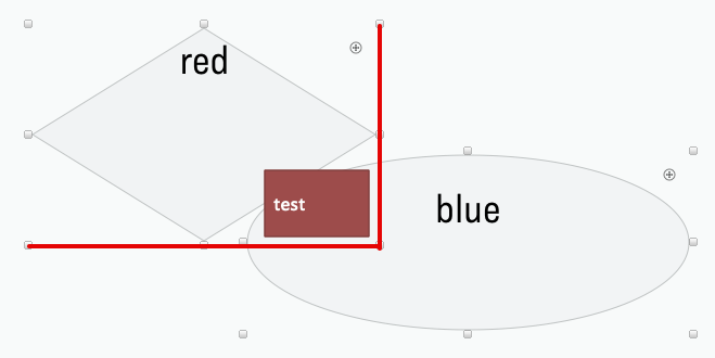
Consider this map with two shaped adornments, each set with an OnAdd to set $Color to the colour named in the adornment. See what happens when we drop a note on the top left corner of the ‘blue’ adornment:
The note overlaps both but is also within the selection area of the ‘red’ one which also happens to be the ‘front-most’ of the two adornments. Thus if a note is dropped into an area within the selection areas (not just the drawn shapes) of two adornments, the action fires for the front (top) one in the visual stack order. I’ve also verified that if you drop a note onto a shaped adornment outside the shape but within/overlapping the adornment’s selection bounding box, the OnAdd fires.
So, if there is a solution to this concept, I suspect it will come from a different implementation. It’s also worth considering how detailed the zoom of the individual state adornment boundaries would need to be. Even if only vector data, some of the lines are quite squiggly (IOW, more data points). Compare Wyoming and Maryland. So that is the status quo as I understand it, but @eastgate continues to surprise with new view ideas…
Each state in its own vector figure exists in OmniGraffle 7 (and prior). It is buried in the stencils. You cannot unfortunately select all the state figures and paste them as individual adornment figures in Tinderbox 7, as far as I can tell. You have to copy/paste 50 states one by one.
And Tinderbox does not paste each figure in the same scale and proportions as the original from OmniGraffle. You have to manually resize each figure to fit.
So – long detour and painful hours of cleanup, but there’s a path from here to there.
And apologies for the sub-literate typing and spelling of the original message, which I just saw again right now. Was trying to edit it on a phone while in the back of a taxicab. That’s an approach I won’t take again!
Yes, but I’m pretty sure we’ll want to be able to do think like as “is this note in South Dakota?”, and take actions like “move this note to New Mexico.”