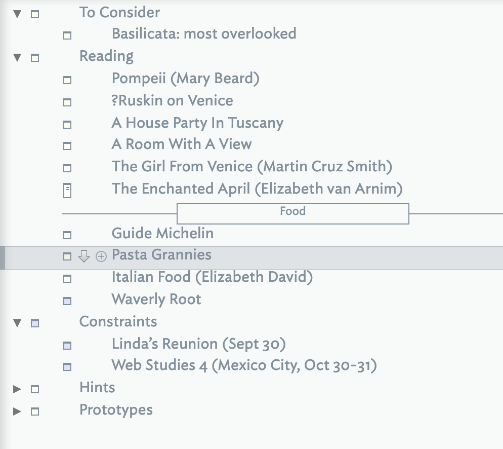
Here’s a common task that might be worth discussing. Later this year (or maybe next), I might be taking a short trip to Italy. I just started a Tinderbox for planning: what do I want to include, and how?
At this point, I have no automation at all: I don’t even know what I’m doing! I imaging I’ll want a map view for brainstorming, and perhaps a different map view for scheduling.
Also: what else is necessary to read? And which film of A Room With A View is best?
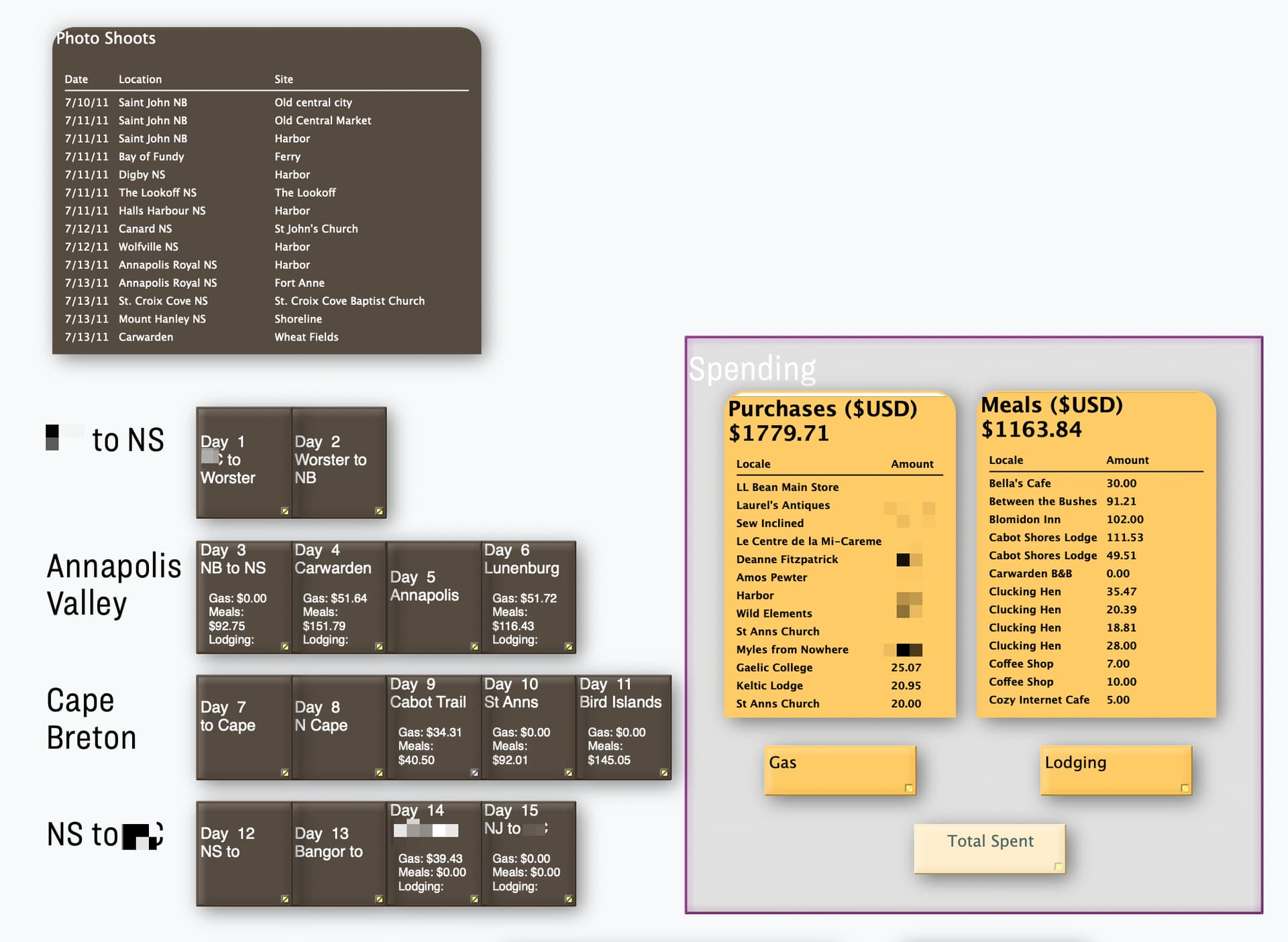
For several years, pre-Covid, whenever i took a trip I created a Tinderbox document to manage info for that trip. I had containers for places to stays, itineraries, daily events logs, etc. I also had lots of attributes to collect mileages, food, event, and lodging costs, and other things. I used a TapForms database to collect spending info and mileage (including snaps of receipts) and in the evening I would export the days’ data to .csv and import to my Tinderbox document to update daily logs. I had a set of nifty dashboards on one of the maps that reported sums for the mileage and spending and a few other milestone datapoints.
Now that pre-Covid-style travel is starting up again, I think I’ll dig out my old Tinderbox file and the TapForms database template and do this again for an long upcoming trip to Greece and Turkey, but the Tinderbox piece will have to wait until after because I’m not lugging the laptop this time. TapForms runs on the iPhone and is a very good friend of Tinderbox, IMO.
(Note: I will not use TapForms for logging data on the phone going forward. The app does not appear to be maintained well anymore, and it does not sync correctly with modern macOS versions. The simplest form-based app to log data on the phone for eventual export to Tinderbox as .csv is the free one we all have: Apple Numbers.)
This prompted me to dust off a couple of old v5 era planning docs (more for conventions than pure travel). They aren’t meant to be complete in anyway, but might help with getting ideas going. I’ve updated both files for current fonts/colours and removed a few non-longer-supported things. Here they are:
Like it say, not ‘complete’. for instance there is no tracking of costs/bookings. Perhaps that’s a place to start unless you’re making your own from scratch.
Here’s a dashboard from a Tinderbox log 12 years ago. Road trip to Nova Scotia. With all the changes in Tinderbox since 2011 I am sure we can come up with something more handsome, but back then I thought this was wonderful.
Prompted by the last, this is an opportunity to leverage other views too. Likely we’ll all have some form of dashboard—whether an explicit container or just a corner of a view (or other?) view. But consider:
Timeline. Not only dates. The view shows links between notes and shows adornments (if they have dates). Timeline bands means you can segment items vertically, e.g. work and non-work or primary events and sundry items etc.
Attribute Browser view. Review notes segmented by attribute values, e.g. which notes use which tags.
Treemap. Look beyond the defaults. If the view plots, for example, total cost per day, the size of any day note/container will indicate the relative expenditure.
The above aren’t necessities for all but just aspects some might find useful and which are easily overlooked.
And (tbd) Posters will eventually have a role to make the trip plan / trip diary a richer experience – geographic maps, route diagrams, images from venues, etc etc
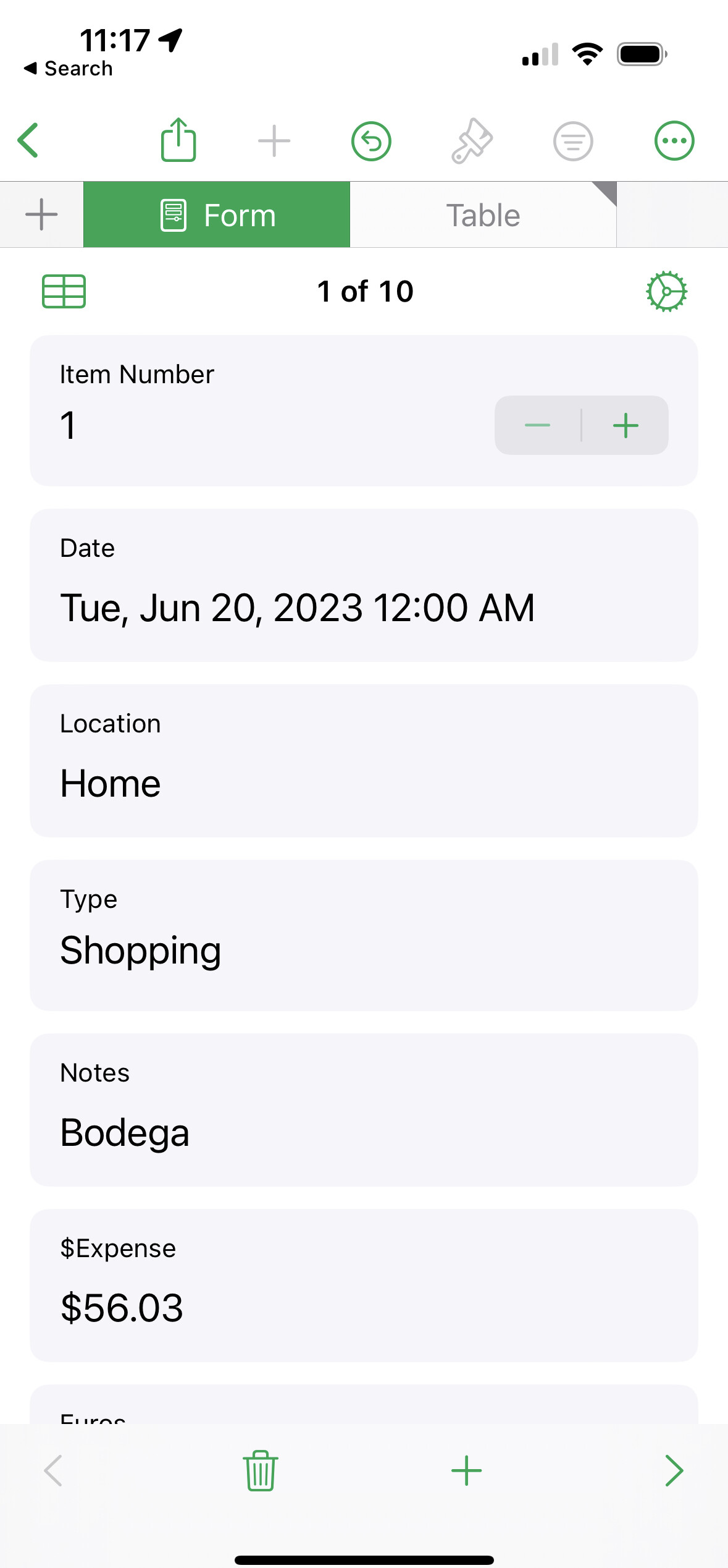
Numbers is my go-to app for entering, well, numbers. For an on-the go form-based solution, Filemaker owners can fashion a little data collecting app with a couple of fields and a big “Enter” button. The generated data is exportable as csv too.
Numbers on iOS provides a form interface, with numerous data types and formats, feeds an exportable table. Setup is quick – a few minutes – and it’s free!
I split the research list into separate lists of Reading and Viewing.
I added my first bits of automation. Notes added to my list of Places To Consider are now automatically assigned the Prototype “Place”, and that prototype takes the name of the note, appends “, Italy”, and puts the result into $Address. That means Get Info:Map tells me where things are, which is really helpful.
Also, I suspect this escapade will be roughly organized from North to South. So, the list of Places To Consider can sort itself by Latitude — something I’d never anticipated.
If I have a “places” container, with notes for destinations, is there a way to put a map on the map for that container that lists all the destinations on the same map. I suppose “all the destinations” means all notes with an $Address. Get Info > Map is fine, but I want to see a persistent map and have multiple destinations showing simultaneously.
Well, you can make a geographic adornment by giving an adornment a Latitude/Longitude pair. And you can get Latitude and Longitude by entering an $Address.
I lived in Italy for ten years (some time ago) and have been back there several times since. Send me a PM if you have any questions I might be able to help with. I lived in the north, and worked at the University of Venice for a short time, and for several years at the University of Verona. There are still substantial cultural and linguistic* differences between the regions of Italy, so I couldn’t tell you much about the centre and the south – not to mention the islands.
*I remember reading a news report while I was living in Italy about a field of opium poppies that had been discovered by the police, and the investigating officer had to find an interpreter to be able to speak to the owner, because the officer was not from the local area. (I wouldn’t be surprised if the inability to understand standard Italian was exaggerated for effect, however!)
Hello,
From reading Atbref, I understood that the Geographic Adornment feature was deprecated in version 9. Am I missing something? Strangely when I tried to use it just now, I did manage to get a map of the region where I live, but entering in $Address didn’t seem to do much.
Tinderbox was creating dozens, sometimes hundreds of unused CVDisplayLink threads to support objects that might be, but were not in fact, geographical adornments. Geographical adornments have been temporarily sent on vacation and will return, after a rest, with better performance.
The release notes for v9.0.0 notes:
Map View
Geographic Adornments are updated more promptly when their location changes.
So, although there was some work done in v9.5.0 , there has never been any statement that Geographic adornments are ready for use again.
If you change the address of a geographic adornment, you should zero out $Latitude and $Longitude. The new address will eventually be translated to coordinates, and the map will be updated.
Hi Mark,
Yes, the translation of the address to coordinates works correctly. What doesn’t seem to happen is the map updating. All of my maps are centered upon my present coordinates.
Maurice